European data from official national sources compiled and harmonized prepared through EuroGeographics is to be included in the Second Administrative Level Boundaries (SALB) programme.
EuroGeographics represents National Mapping, Cadastral and Land Registry Authorities from the whole of geographical Europe, provided its 1:1 million scale topographic open dataset, EuroGlobalMap to assist the project’s aim of compiling global administrative boundaries data from authoritative sources.
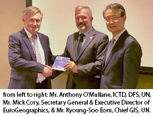 Mr. Mick Cory, Secretary General and Executive Director of EuroGeographics presented the dataset to Mr. Kyoung-Soo Eom, Chief, Geospatial Information Section, United Nations and Mr. Anthony O’Mullane, Director, Information and Communications Technology Division, Department of Field Support, United Nations during the Seventh Session of the United Nations Committee of Experts on Global Geospatial Information Management (UN-GGIM) in New York. EuroGeographics also anounced its contribution to SALB in a press release.
The dataset covering countries over the Europe region will be integrated in the SALB data holdings and further validated by countries through the SALB process. The SALB welcomes this important contribution from Europe and looks forward to the continued cooperation with EuroGeographics as a regional partner of the SALB programme.