"The data needs for the Sustainable Development Goals are great, and time is not on our side.
Reliable, timely, accessible and disaggregated geospatial information must be brought to bear to measure progress, inform decision-making and ensure effective and inclusive national and sub-national programs."
- António Guterres, Secretary-General of the United Nations
Objectives
The Second Administrative Level Boundaries (SALB) programme objective is to promote accessible, interoperable and global data and information on subnational units and boundaries, or common geographies, for better decisions, stronger support to people and planet and to monitor the Sustainable Development Goals.
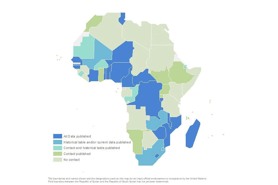
The SALB programme, in close collaboration with National Geospatial Information Authorities* each Member States of the United Nations, aims to make available a global repository of authoritative information and geospatial data about the administrative units structure of countries down to the second subnational level, and through time.
Specifically SALB objectives are to collect, maintain and share:
| Contact information of the National Geospatial Information Authority responsible for administrative units and boundaries | |
| Geospatial data for administrative units and boundaries for first and second level below national, at 1:1 million scale | |
| Historical tables providing changes of national administrative units and names for the first and second level below national |
The above data and information is a public good available to Members States, international organizations, and the international civil society including the general public, statisticians, geospatial experts and researchers.
Global Agenda
The SALB programme aligns with priorities of different global agendas as set forth by Member States in the context of several General Assembly, ECOSOC Resolutions, Committees and Group of Experts recommendations.
Rio + 20 : The Future We Want (General Assembly, RES/66/288)
SALB as an authoritative geospatial dataset on administrative boundaries supports the provision of:
“reliable geospatial information for sustainable development policy making, programming and project operations” [§ 274]
“comprehensive hazard and risk assessments, and knowledge and information sharing, including reliable geospatial information” [§ 187]
2030 Agenda for Sustainable Development (General Assembly, RES/70/1)
SALB can play a crucial role in providing reliable global geospatial information to support measuring and monitoring the 2030 Sustainable Development Goals agenda and in particular through the integration of statistics and geospatial data. SALB contributes to this global effort as it allows to:
“increase significantly the availability of high-quality, timely and reliable data disaggregated by income, gender, age […] and geographic location” [§ 17.18 and 74(g)]
“promote transparent and accountable scaling-up of appropriate public-private cooperation to exploit the contribution to be made by a wide range of data […] and geospatial information, while ensuring national ownership in supporting and tracking progress” of the SDGs [§ 76]
“report on the Sustainable Development Goals to be prepared by the Secretary-General in cooperation with the United Nations system, based on the global indicator framework and data produced by national statistical systems and information collected at the regional level’ [§ 83]
United Nations Committee of Expert on Global Geospatial Management (UN-GGIM)
The United Nations Committee of Experts on Global Geospatial Information Management, established under resolution 2011/24 by the Economic and Social Council (ECOSOC), during its sixth session on the “Determination of global fundamental geospatial data themes”:
highlighted administrative boundaries as a priority “core global fundamental geospatial data theme”
“noted the importance of the availability of seamless global administrative level boundary data for countries, and continuing to contribute to the SALB”
United Nations Group of Experts on Geographic Names (UNGEGN)
Finally, SALB also contributes to the United Nations Group of Experts on Geographic Names mandate by:
promoting the recording of locally-used names reflecting the languages and traditions of a country for administrative names
promoting the use of these names internationally and use of a single scientifically-based romanization system for administrative names
making mapping organizations aware of the importance of using standardized geographical names


