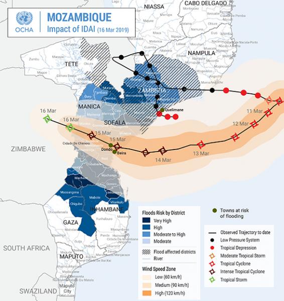
In March and April 2019, Mozambique was hit by two consecutive tropical cyclones that left a trail of death, damage and destruction in their path. As the first cyclone approached the coast of Mozambique, the authoritative geospatial dataset on administrative boundaries, provided by the Cenacarta (Centro Nacional de Cartografia e Teledeteção), was published on the SALB website.
The reliability of the standardized geospatial information made available in the context of SALB was used as a critical reference by the Organization for the Coordination of Humanitarian Affairs (OCHA) in its coordination of humanitarian operations and response. The data was complemented and disseminated by OCHA to all the humanitarian actors as a Common Operational Dataset (COD). CODs are the ‘best available’ authoritative reference datasets needed to support operations and decision making in a humanitarian response.
The readily available administrative data provided a fundamental dataset for humanitarian operations on the ground and a key data framework for cyclone damage assessments, as well as a reliable source to present cyclone impact, operational presence, and pleas for mobilizing resources to support affected populations, as presented in the Humanitarian snapshot on the cyclones.
As identified in the Rio+20: The Future We Want (General Assembly, RES/66/288), reliable geospatial information is critical for “sustainable development policy making, programming and project operations” [para 274] and for “comprehensive hazard and risk assessments” [para 187]. In the context of Climate Action, Sustainable Development Goal 13 of the 2030 Agenda, developed countries have committed to jointly mobilizing $100 billion per year by 2020 to address climate-related needs of developing countries, which often exacerbate disasters. The SALB programme, with the support of its partners, such as OCHA, promotes reliable data while ensuring national ownership and allows, through the provision of common geographies, facilitation of the integration of statistical data and geospatial information, contributing to overall efforts in analyzing natural disaster damage and use data for action and monitoring in the context of humanitarian aid to affected countries and populations.