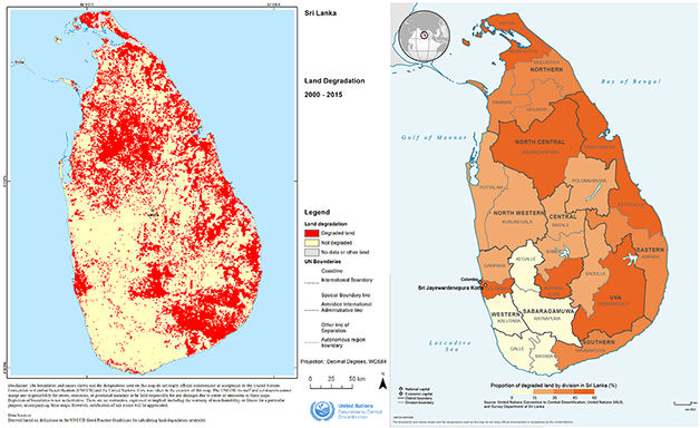
Land degradation, resulting from unsustainable land use, is one of the most pressing environmental issues impacting an estimated one-fifth of the Earth’s surface and affecting more than 3.2 billion people globally. Land degradation is defined by the United Nations Convention to Combat Desertification (UNCCD) as “the reduction or loss of the biological or economic productivity and complexity of rainfed cropland, irrigated cropland, or range, pasture, forest and woodlands resulting from a combination of pressures, including land use and management practices”. At the current trend of unsustainable land management, it is estimated that 95 percent of Earth’s Land could become degraded by 2050.
Sustainable Development Goal (SDG) 15 promotes “Life on Land” and SDG target 15.3 aims at combating desertification and restoring degraded land and soil to achieve a land degradation-neutral world by 2030. As of today, 128 countries have committed to setting voluntary targets to achieve Land Degradation Neutrality, and 70 countries have officially endorsed those targets, including Sri Lanka (Land Degradation Neutrality Targets for Sri Lanka, 2017).
Sri Lanka has seen an exponential increase in land degradation over the last few decades, with consequences of increased poverty, reduction of land productivity, and loss of biodiversity. Being a signatory of the three Rio Conventions and implementing local strategic programs, Sri Lanka has committed to the goal of Land Degradation Neutrality by 2030 implementing 25 programs within a 10-year period from 2014 to 2024.
Reliable geospatial information is an essential mean that countries and the international community need to monitor progress, implement actions and report on the SDGs. The UNCCD, as the custodian agency of SDG indicator 15.3.1, has been collecting spatial data on land degradation from countries since 2018. This land degradation data referring to the period 2000 - 2015 has been received from Sri Lanka. Combining the administrative unit’s data collected in the context of the SALB programme, provided by the Survey Department of Sri Lanka, the land degradation data can be disaggregated by districts, or divisions, to identify priority areas for national programs and international aid, including operations and support from the United Nations agencies, funds and programmes.